
Workshop to Share Lessons Learned from Large Scale Participatory Mapping (PPSL)
Posting Date
23-26 June 2014
Tabanan, Bali
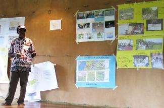
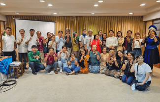
A workshop to share learning from ongoing Large Scale Participatory Mapping Large Scale Participatory Mapping (Pemetaan Partisipatif Skala Luas - PPSL) was held in Tabanan, Bali. Participants included community representatives from Talang Mamak-Riau, Tamambalo-West Kalimantan, Iban Jalailintang-Kapuas Hulu West Kalimantan, Toraja, Nambluong and Klisi Kemtuik-papua, Malamoi-West Papua, and from Samdhana partner organisations including AMAN, AMAN Toraya, Lanting Borneo, AMAN Indragiri Hulu, and JKPP.
The workshop began with introductions by all participants in their local language. Participants were then allocated time to put together introductory presentations on PPSL implementation in their respective areas for the first day, and more detailed information on approach and methodology on the second day. While PPSL is a standardized methodology, its articulation and implementation on the ground depends heavily on local contexts and circumstances. In particular, the process of demarcating and verifying areas and landmarks of cultural significance, or with conflicting claims, can take varying amounts of time, requiring community facilitators to oversee locally appropriate methods for clarification.
The workshop provided an opportunity for participants to learn from various methods for implementation of PPSL, as well as discuss challenges faced and help each other brainstorm potential solutions. One community facilitator, Abu Sanar, from AMAN INHU expressed the difficulties facing his community, where oil palm plantations have taken up the mantle of colonialists, followed by an authoritarian state, to now render the community landless.
As well, the workshop served as an avenue to benefit from the wealth of experiences in securing community tenure and rights recognition over their natural resources. This includes sharing experiences on the impact and results of both the mapping process and the final output. Communities have had a variety of experience working to integrate the outputs of participatory mapping into relevant local and provincial government processes, including spatial planning.
The wealth of experiences at the workshop was a diverse one. For example, one participant, Pak Elly Waicang from Nambluong, Papua, is over 70 years old and has been actively involved in various community mapping initiatives for well over the past few decades. Pak Elly shared Nambluong with other members of the community.
Ibu Ela from Tamambalo has been involved in PPSL since 2012. She spoke to the scope of work and the impact of the PPSL process on her community.
In line with its vision and mission, the Samdhana Institute provides support for communities working to safeguard tenure rights and community management of natural resources. One means of doing so is through PPSL, a method developed by Native Land, a Non-Governmental Organisation (NGO) from the United Sates of America that developed the method as a means to help communities garner recognition of their rights over territories.
For the past two years, Samdhana has given support to several communities to conduct PPSL. This includes the community of Talang Mamak, the community of Malamoi, the community of Yei in Merauke, and the community of Dayak Iban.
Tabanan, Bali
A workshop to share learning from ongoing Large Scale Participatory Mapping Large Scale Participatory Mapping (Pemetaan Partisipatif Skala Luas - PPSL) was held in Tabanan, Bali. Participants included community representatives from Talang Mamak-Riau, Tamambalo-West Kalimantan, Iban Jalailintang-Kapuas Hulu West Kalimantan, Toraja, Nambluong and Klisi Kemtuik-papua, Malamoi-West Papua, and from Samdhana partner organisations including AMAN, AMAN Toraya, Lanting Borneo, AMAN Indragiri Hulu, and JKPP.
The workshop began with introductions by all participants in their local language. Participants were then allocated time to put together introductory presentations on PPSL implementation in their respective areas for the first day, and more detailed information on approach and methodology on the second day. While PPSL is a standardized methodology, its articulation and implementation on the ground depends heavily on local contexts and circumstances. In particular, the process of demarcating and verifying areas and landmarks of cultural significance, or with conflicting claims, can take varying amounts of time, requiring community facilitators to oversee locally appropriate methods for clarification.
The workshop provided an opportunity for participants to learn from various methods for implementation of PPSL, as well as discuss challenges faced and help each other brainstorm potential solutions. One community facilitator, Abu Sanar, from AMAN INHU expressed the difficulties facing his community, where oil palm plantations have taken up the mantle of colonialists, followed by an authoritarian state, to now render the community landless.
As well, the workshop served as an avenue to benefit from the wealth of experiences in securing community tenure and rights recognition over their natural resources. This includes sharing experiences on the impact and results of both the mapping process and the final output. Communities have had a variety of experience working to integrate the outputs of participatory mapping into relevant local and provincial government processes, including spatial planning.
The wealth of experiences at the workshop was a diverse one. For example, one participant, Pak Elly Waicang from Nambluong, Papua, is over 70 years old and has been actively involved in various community mapping initiatives for well over the past few decades. Pak Elly shared Nambluong with other members of the community.
Ibu Ela from Tamambalo has been involved in PPSL since 2012. She spoke to the scope of work and the impact of the PPSL process on her community.
In line with its vision and mission, the Samdhana Institute provides support for communities working to safeguard tenure rights and community management of natural resources. One means of doing so is through PPSL, a method developed by Native Land, a Non-Governmental Organisation (NGO) from the United Sates of America that developed the method as a means to help communities garner recognition of their rights over territories.
For the past two years, Samdhana has given support to several communities to conduct PPSL. This includes the community of Talang Mamak, the community of Malamoi, the community of Yei in Merauke, and the community of Dayak Iban.
Stories
Samdhana Institute Opens Manila Office at Manila Observatory
Festival PARARA 2023: Celebrating Local Entrepreneurship and Indigenous Products
Partners' solidarity for World's Indigenous Peoples Day
Grant Advisers Meeting in Chiang Mai