
Drone for Community Mapping
Posting Date
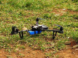
Drones, or unmanned aerial vehicles, can be used for beneficial conservation activities, including monitoring and mapping by communities.
Drones are remote controlled using radio waves, though they can also fly a charted, pre-programmed course. The technical accuracy of drone-compiled data can serve as an ideal complement to community mapping work, and be adjusted to suit specific mapping objectives.
Drones can carry a camera on an aerial vehicle to take pictures or videos. The images are then sent using radio transmitter to the receiver or ground station. The operator will receive images similar to those viewed from an airplane cockpit.
So far drone-use has been limited to military activities, aerial photography, aerial filming, monitoring physical infrastructures, and use by plantations. Currently, drones are deployed by plantations and estates to gather Near Infrared (NIR) images and support development of the Normalized Difference Vegetation Index (NDVI).
Drones can be utilized to support participatory mapping but is not meant to replace participatory mapping, explained Irendra Radjawali, researcher and Community Drone specialist during the “Drones for Mapping discussion held by Samdhana Institute in Bogor, 10 June 2014.
According to a researcher from Leibniz Center for Tropical Marine Ecology-Bremen in Germany, drones can help monitor ecosystem transformations occurring every second, hour, and day. Indeed, drones can be a positive example of the utilization of science and technology in the public domain, for public good.
Unfortunately, drone technology is still prohibitively expensive. Existing systems comprising of drones cost approximately USD 30,000 and excludes software. Drones constructed locally in Indonesia cost IDR 300 million, with 12 days flight capability and a range of 18,000 hectares.
For drones to be able to complement community activities, they need to be relatively affordable with good cost-benefit ratios, and also be simple, practical, and able to be collectively operated. Drones can be integrated with relatively simple geo-referencing, and the data obtained can be integrated easily with a geographic information system (GIS).
We can develop one at a figure of around IDR 3-5 million. We can also develop a multicopter at IDR 10 million, Radja added.
Community Drones have already completed a trial mapping for Forest Product Extraction Licenses for Customary Law Society (IUPHHK-MHA) in Sepse Village, Biak, Papua; subak irrigation mapping in Jatiluwih Village, Bali; and hydraulic lake draining due to oil palm plantation in Sintang District, West Kalimantan.
In Biak, the first drone flew for 15 minutes, covering 30 hectares. The Quadcopter trials ran for 15 minute flight times, covering 50 hectares. Trials in Jatiluwih Village, Bali ran for 15 minutes over 68 hectares, and the results were successfully transformed into 3-D with visible contours. In Sintang District, a 30 ha area was mapped from 250 m asl elevation, from a 14 minute flight.
Based on the series of trials, detailed maps of 50-60 hectares were produced by a multicopter in flight for 15 minutes. Maps with 300-400 hectares detail were produced with fixed/Flying Wing drone through 45-60 minute flights. The resulting ortophoto maps are geo-referenced and transformed into a 3-dimensional mosaic.
Still, some challenges remain to drone use, in particular security, difficulties in identifying commercial flight routes, and developing ground control station (GCS). Drone batteries currently last for one hour , and have a 400 hectare radius at most. In addition to the need for good hardware and training a field-ready team, there are also risks of drones going missing, falling, or producing poor quality photos.
As well, it is uncertain whether expanded drone usage will lead to change in the regulatory environment. Currently, there are no regulations in Indonesia concerning drone instrument functions, flight modes, maximum heights, and flight radius.
Ultimately, drones can be optimized for fast and detailed mapping (5,000 hectares in one week), but this would require increasing both the ranging ability and improving photo quality and accuracy with better ground control points and NDVI images. As well, local community ownership and participation, as well as advocacy through mapping, research, and policy intervention are also key.
Stories
Samdhana Institute Opens Manila Office at Manila Observatory
Festival PARARA 2023: Celebrating Local Entrepreneurship and Indigenous Products
Partners' solidarity for World's Indigenous Peoples Day
Grant Advisers Meeting in Chiang Mai